
Make a donation
Gear up for your next adventure:
As an Amazon Associate, this site earns from qualifying purchases at no extra cost to you.
Ozhukarai Taluk topographic map
Click on the map to display elevation.
Make a donation
Gear up for your next adventure:
As an Amazon Associate, this site earns from qualifying purchases at no extra cost to you.
About this map
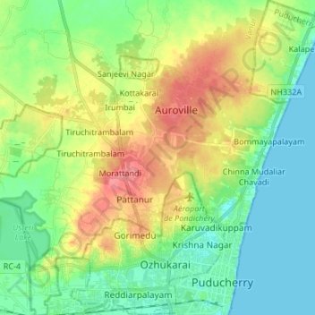
Name: Ozhukarai Taluk topographic map, elevation, terrain.
Location: Ozhukarai Taluk, Puducherry district, Puducherry, India (11.92058 79.76624 12.05098 79.87460)
Average elevation: 75 ft
Minimum elevation: 0 ft
Maximum elevation: 207 ft
Make a donation
Gear up for your next adventure:
As an Amazon Associate, this site earns from qualifying purchases at no extra cost to you.
Other topographic maps
Click on a map to view its topography, its elevation and its terrain.
Puducherry
India > Puducherry > Puducherry Taluk
The topography of Pondicherry is the same as that of coastal Tamil Nadu. Pondicherry's average elevation is at sea level and includes a number of sea inlets, referred to locally as "backwaters". Pondicherry experiences extreme coastal erosion as a result of a breakwater constructed in 1989, just to the south…
Average elevation: 33 ft
Make a donation
Gear up for your next adventure:
As an Amazon Associate, this site earns from qualifying purchases at no extra cost to you.
Make a donation
Gear up for your next adventure:
As an Amazon Associate, this site earns from qualifying purchases at no extra cost to you.
Puducherry
India > Puducherry > Puducherry Taluk
The topography of Pondicherry is the same as that of coastal Tamil Nadu. Pondicherry's average elevation is at sea level and includes a number of sea inlets, referred to locally as "backwaters". Pondicherry experiences extreme coastal erosion as a result of a breakwater constructed in 1989, just to the south…
Average elevation: 33 ft