
Make a donation
Gear up for your next adventure:
As an Amazon Associate, this site earns from qualifying purchases at no extra cost to you.
Parque Forestal topographic map
Click on the map to display elevation.
Make a donation
Gear up for your next adventure:
As an Amazon Associate, this site earns from qualifying purchases at no extra cost to you.
About this map
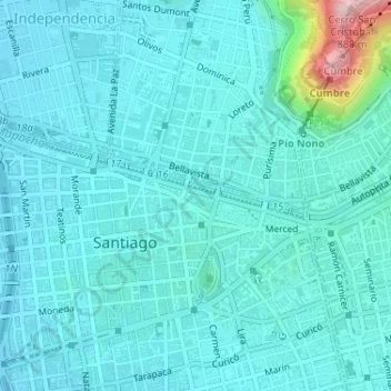
Name: Parque Forestal topographic map, elevation, terrain.
Average elevation: 1,916 ft
Minimum elevation: 1,781 ft
Maximum elevation: 2,835 ft
Make a donation
Gear up for your next adventure:
As an Amazon Associate, this site earns from qualifying purchases at no extra cost to you.
Other topographic maps
Click on a map to view its topography, its elevation and its terrain.
La Reina
Chile > Región Metropolitana de Santiago > Provincia de Santiago > Santiago
Average elevation: 2,835 ft
Recoleta
Chile > Región Metropolitana de Santiago > Provincia de Santiago > Santiago
Average elevation: 1,883 ft
San Miguel
Chile > Región Metropolitana de Santiago > Provincia de Santiago > Santiago
Average elevation: 1,798 ft
Palacio de La Moneda
Chile > Región Metropolitana de Santiago > Provincia de Santiago > Santiago
Average elevation: 1,831 ft
Make a donation
Gear up for your next adventure:
As an Amazon Associate, this site earns from qualifying purchases at no extra cost to you.
Maipú
Chile > Región Metropolitana de Santiago > Provincia de Santiago > Santiago
Inaugurado el 13 de septiembre de 1910, este es el único monumento que responde a una orden directa de Bernardo O'Higgins. En la Gaceta Ministerial n.º 44 del sábado 13 de junio de 1818, O'Higgins y Zenteno decretaron: "En lo más descubierto de la loma, teatro principal de la batalla y de nuestros…
Average elevation: 1,654 ft
Las Condes
Chile > Región Metropolitana de Santiago > Provincia de Santiago > Santiago
Average elevation: 2,572 ft
Recoleta
Chile > Región Metropolitana de Santiago > Provincia de Santiago > Santiago
Average elevation: 1,824 ft
La Florida
Chile > Región Metropolitana de Santiago > Provincia de Santiago > Santiago
Average elevation: 2,129 ft
Make a donation
Gear up for your next adventure:
As an Amazon Associate, this site earns from qualifying purchases at no extra cost to you.
El Bosque
Chile > Región Metropolitana de Santiago > Provincia de Santiago > Santiago
Average elevation: 1,923 ft
Parque Forestal
Chile > Región Metropolitana de Santiago > Provincia de Santiago > Santiago
Average elevation: 1,926 ft
Recoleta
Chile > Región Metropolitana de Santiago > Provincia de Santiago > Santiago
Average elevation: 1,824 ft
Lo Espejo
Chile > Región Metropolitana de Santiago > Provincia de Santiago > Santiago
Average elevation: 1,759 ft
Make a donation
Gear up for your next adventure:
As an Amazon Associate, this site earns from qualifying purchases at no extra cost to you.