Geolocate

Sparta topographic map

Click on the map to display elevation.

About this map

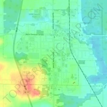
Name: Sparta topographic map, elevation, terrain.

Location: Sparta, Sparta Township, Kent County, Michigan, United States (43.14188 -85.73014 43.16881 -85.68801)

Average elevation: 771 ft

Minimum elevation: 719 ft

Maximum elevation: 876 ft

Kent County trails, hiking, mountain biking, running and outdoor activities

Other topographic maps

Click on a map to view its topography, its elevation and its terrain.

Harvard Lake

United States > Michigan > Kent County > Harvard

Average elevation: 876 ft

Grattan

United States > Michigan > Kent County

Average elevation: 856 ft

Lookout Park

United States > Michigan > Kent County > Grand Rapids

Average elevation: 669 ft

Crescent Park

United States > Michigan > Kent County > Grand Rapids

Average elevation: 669 ft

Kettle Lake

United States > Michigan > Kent County

Average elevation: 784 ft

Cobb Lake

United States > Michigan > Kent County > Bowne Township

Average elevation: 827 ft

Grattan

United States > Michigan > Kent County

Average elevation: 856 ft

Parnell

United States > Michigan > Kent County > Grattan Township

Average elevation: 850 ft

Richmond Park

United States > Michigan > Kent County > Grand Rapids

Average elevation: 663 ft

Creekside Park

United States > Michigan > Kent County > Lowell

Average elevation: 659 ft

Gear up for your next adventure:

🗺️NatGeo Topo Maps - High-quality waterproof printed topographic maps of US Parks
🩳Quick‑Dry Hiking Shorts - Comfortable and quick‑dry shorts for summer hiking
🪑Ultralight Camp Chairs - Portable seating for resting after a long day of mapping
📚USA Hiking Guide Books - Top trail guides and map books
🪶LED Camping Lantern - Bright lantern for camp lighting

As an Amazon Associate, this site earns from qualifying purchases at no extra cost to you.