
Port Dover topographic map
Click on the map to display elevation.
About this map
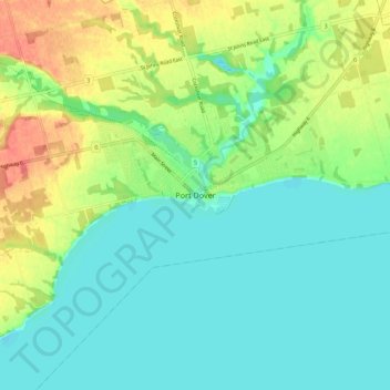
Name: Port Dover topographic map, elevation, terrain.
Location: Port Dover, Norfolk County, Ontario, N0A 1N0, Canada (42.74457 -80.24052 42.82457 -80.16052)
Average elevation: 614 ft
Minimum elevation: 554 ft
Maximum elevation: 728 ft
Other topographic maps
Click on a map to view its topography, its elevation and its terrain.
Turkey Point Provincial Park
Canada > Ontario > Norfolk County > Turkey Point
Average elevation: 630 ft
Black Creek Conservation Area
Canada > Ontario > Norfolk County > Port Dover
Average elevation: 620 ft