
Make a donation
Gear up for your next adventure:
As an Amazon Associate, this site earns from qualifying purchases at no extra cost to you.
Ehlange topographic map
Click on the map to display elevation.
Make a donation
Gear up for your next adventure:
As an Amazon Associate, this site earns from qualifying purchases at no extra cost to you.
About this map
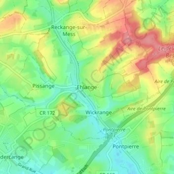
Name: Ehlange topographic map, elevation, terrain.
Average elevation: 1,024 ft
Minimum elevation: 915 ft
Maximum elevation: 1,184 ft
Make a donation
Gear up for your next adventure:
As an Amazon Associate, this site earns from qualifying purchases at no extra cost to you.
Other topographic maps
Click on a map to view its topography, its elevation and its terrain.
Differdange
Luxembourg > Canton Esch-sur-Alzette
Differdange has an altitude of 293 meters, the highest point of the municipality being at 427,1m at Koufeld.
Average elevation: 1,155 ft
Differdange
Luxembourg > Canton Esch-sur-Alzette
The town is located in the plateau of the river Chiers, a tributary of the river Meuse which takes its source in the section of Oberkorn. Differdange has an altitude of 293 meters, the highest point of the municipality being at 427,1m at Koufeld. The commune spreads over 2,215 hectares. Its territory borders…
Average elevation: 1,155 ft
Make a donation
Gear up for your next adventure:
As an Amazon Associate, this site earns from qualifying purchases at no extra cost to you.
Make a donation
Gear up for your next adventure:
As an Amazon Associate, this site earns from qualifying purchases at no extra cost to you.
Make a donation
Gear up for your next adventure:
As an Amazon Associate, this site earns from qualifying purchases at no extra cost to you.