
Salcombe topographic map
Click on the map to display elevation.
About this map
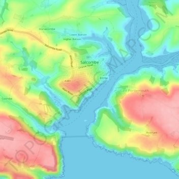
Name: Salcombe topographic map, elevation, terrain.
Average elevation: 164 ft
Minimum elevation: -7 ft
Maximum elevation: 446 ft
Other topographic maps
Click on a map to view its topography, its elevation and its terrain.
Higher Wonton
United Kingdom > England > Devon > South Hams > Avonwick > Higher Wonton
Average elevation: 413 ft
Lower Holditch
United Kingdom > England > Devon > South Hams > West Alvington
Average elevation: 226 ft
Yeovil Rock
United Kingdom > England > Devon > South Hams > Hope > Inner Hope
Average elevation: 52 ft
Strete Gate
United Kingdom > England > Devon > South Hams > Strete > Strete Gate
Average elevation: 135 ft
Brent Hill Hifort
United Kingdom > England > Devon > South Hams > Didworthy > Shipley Bridge
Average elevation: 633 ft
Lower Batson
United Kingdom > England > Devon > South Hams > Salcombe > East Portlemouth
Average elevation: 141 ft
Lower Batson
United Kingdom > England > Devon > South Hams > Salcombe > East Portlemouth
Average elevation: 141 ft