Geolocate

Helicon topographic map

Click on the map to display elevation.

About this map

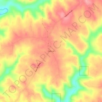
Name: Helicon topographic map, elevation, terrain.

Location: Helicon, Winston County, Alabama, United States (34.10621 -87.15834 34.14621 -87.11834)

Average elevation: 761 ft

Minimum elevation: 535 ft

Maximum elevation: 889 ft

Other topographic maps

Click on a map to view its topography, its elevation and its terrain.

Haleyville

United States > Alabama > Winston County

Average elevation: 856 ft

Double Springs

United States > Alabama > Winston County

Average elevation: 741 ft

Addison

United States > Alabama > Winston County

Average elevation: 778 ft

Arley

United States > Alabama > Winston County

Average elevation: 682 ft

Gear up for your next adventure:

🛠️Outdoor Gear Repair Kit - Essential tools to fix gear on the trail
🪶Multi‑Purpose Knife - Useful blade for camp and trail
Camping Coffee Makers - Enjoy premium coffee at the summit or campsite
🛌Ultralight Sleeping Bags - Compact down bags for cold nights in the wilderness
🎒Gear Packing Cubes - Organize your backpack efficiently

As an Amazon Associate, this site earns from qualifying purchases at no extra cost to you.