Union Bridge topographic map
Interactive map
Click on the map to display elevation.
About this map

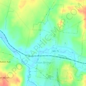
Name: Union Bridge topographic map, elevation, terrain.
Location: Union Bridge, Carroll County, Maryland, United States (39.56252 -77.18594 39.58659 -77.16102)
Average elevation: 453 ft
Minimum elevation: 381 ft
Maximum elevation: 577 ft
Carroll County trails, hiking, mountain biking, running and outdoor activities
Other topographic maps
Click on a map to view its topography, its elevation and its terrain.

Union Mills Homestead Park
United States > Maryland > Carroll County > Union Mills
Average elevation: 640 ft

Mount Airy
United States > Maryland > Carroll County > Mount Airy > Mount Airy
The town was originally settled in the early 1830s by a core group of six families. Dorsey, Davis and Bussard were the most prominent names in that first settlement, which was followed closely by the construction of the B & O railroad line in 1831. Because Mount Airy sits at an elevation of 830 feet (250 m), a…
Average elevation: 712 ft