Geolocate

Oceanside topographic map

Click on the map to display elevation.

About this map

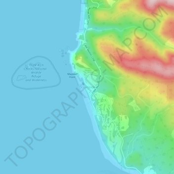
Name: Oceanside topographic map, elevation, terrain.

Location: Oceanside, Tillamook County, Oregon, 97134, United States (45.43945 -123.98856 45.47945 -123.94856)

Average elevation: 203 ft

Minimum elevation: -16 ft

Maximum elevation: 1,010 ft

Tillamook County trails, hiking, mountain biking, running and outdoor activities

Other topographic maps

Click on a map to view its topography, its elevation and its terrain.

Nehalem Bay

United States > Oregon > Tillamook County

Average elevation: 108 ft

Neahkahnie Beach

United States > Oregon > Tillamook County

Average elevation: 331 ft

Seal Rock

United States > Oregon > Tillamook County > Oceanside

Average elevation: 36 ft

Beaver

United States > Oregon > Tillamook County > Beaver

Average elevation: 253 ft

Netarts

United States > Oregon > Tillamook County > Netarts

Average elevation: 115 ft

Cloverdale

United States > Oregon > Tillamook County > Cloverdale

Average elevation: 305 ft

Gear up for your next adventure:

🪶Camping Sleeping Pad - Comfortable sleeping pad for backpacking
🪶Camp Gear Gift Set - Perfect gift bundle for outdoor fans
🧣Hiking Neck Gaiter - Multi‑use neck protection for outdoor weather
🌡️Handheld Weather Meters - Measure wind, temp, and pressure for safe mountain travel
🥾Hiking Shoes - Durable and comfortable shoes for trail hiking

As an Amazon Associate, this site earns from qualifying purchases at no extra cost to you.