Geolocate

Nehalem Bay topographic map

Interactive map

Click on the map to display elevation.

About this map

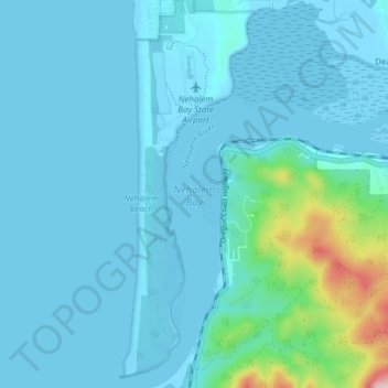
Name: Nehalem Bay topographic map, elevation, terrain.

Location: Nehalem Bay, Tillamook County, Oregon, United States (45.65547 -123.93878 45.70884 -123.88470)

Average elevation: 108 ft

Minimum elevation: -10 ft

Maximum elevation: 1,040 ft

Tillamook County trails, hiking, mountain biking, running and outdoor activities

Other topographic maps

Click on a map to view its topography, its elevation and its terrain.

Cascade Head

United States > Oregon > Tillamook County

Average elevation: 164 ft

Netarts

United States > Oregon > Tillamook County

Average elevation: 144 ft

Oceanside

United States > Oregon > Tillamook County

Average elevation: 203 ft

Fairview

United States > Oregon > Tillamook County

Average elevation: 52 ft

Seal Rock

United States > Oregon > Tillamook County > Oceanside

Average elevation: 36 ft

Netarts Bay

United States > Oregon > Tillamook County

Average elevation: 13 ft

Cape Kiwanda

United States > Oregon > Tillamook County

Average elevation: 30 ft

Brighton

United States > Oregon > Tillamook County > Brighton

Average elevation: 200 ft