Geolocate

Bremen topographic map

Click on the map to display elevation.

👉 Easily get elevation data in JSON, GeoTIFF and KML formats using Elevation API
Thank you for supporting this site ❤️
Make a donation

About this map

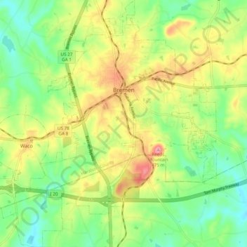
Name: Bremen topographic map, elevation, terrain.

Location: Bremen, Haralson County, Georgia, 30110, United States (33.67035 -85.19439 33.74969 -85.10934)

Average elevation: 1,276 ft

Minimum elevation: 1,086 ft

Maximum elevation: 1,549 ft

Haralson County trails, hiking, mountain biking, running and outdoor activities

Other topographic maps

Click on a map to view its topography, its elevation and its terrain.

Draketown

United States > Georgia > Haralson County

Average elevation: 1,194 ft

Waco

United States > Georgia > Haralson County > Waco

Average elevation: 1,280 ft

Gear up for your next adventure:

🧯Emergency Survival Kit - All‑in‑one survival essentials for the backcountry
🪶Trail Camera - Capture wildlife on your hikes
Backpacking Tent - Lightweight and durable tent for multi‑day hikes
📚Navigation Handbooks - Master the art of reading topographic maps and using a compass
🗃️Trail First Aid Kit - Essential kit for outdoor injuries and emergencies

As an Amazon Associate, this site earns from qualifying purchases at no extra cost to you.