Geolocate

Hamilton topographic map

Click on the map to display elevation.

About this map

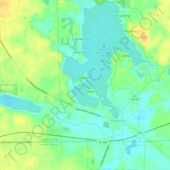
Name: Hamilton topographic map, elevation, terrain.

Location: Hamilton, Steuben County, Indiana, United States (41.52133 -84.93662 41.56363 -84.89937)

Average elevation: 928 ft

Minimum elevation: 883 ft

Maximum elevation: 1,004 ft

Steuben County trails, hiking, mountain biking, running and outdoor activities

Other topographic maps

Click on a map to view its topography, its elevation and its terrain.

Berlien

United States > Indiana > Steuben County

Average elevation: 1,024 ft

York

United States > Indiana > Steuben County

Average elevation: 1,050 ft

Alvarado

United States > Indiana > Steuben County

Average elevation: 958 ft

Metz

United States > Indiana > Steuben County

Average elevation: 974 ft

Pleasant Lake

United States > Indiana > Steuben County

Average elevation: 974 ft

Gear up for your next adventure:

🧦Merino Wool Socks - Moisture-wicking, blister-preventing socks for long treks
🧺Microfiber Travel Towels - Compact and fast-drying towels for trail use
🧢Outdoor Hiking Hat - Sun protection hat for outdoor explorers
🌲Outdoor Survival Books - Best books on survival skills
🔭Telescopic Hiking Pole - Adjustable pole for hiking stability

As an Amazon Associate, this site earns from qualifying purchases at no extra cost to you.