Geolocate

Chulafinnee topographic map

Click on the map to display elevation.

About this map

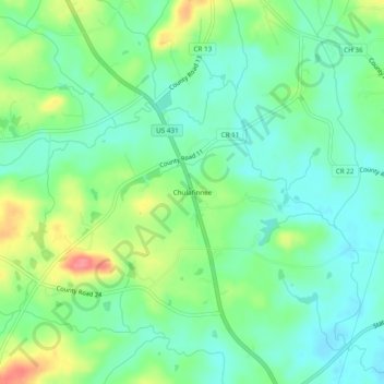
Name: Chulafinnee topographic map, elevation, terrain.

Location: Chulafinnee, Cleburne County, Alabama, United States (33.52539 -85.66885 33.56539 -85.62885)

Average elevation: 883 ft

Minimum elevation: 801 ft

Maximum elevation: 1,053 ft

Cleburne County trails, hiking, mountain biking, running and outdoor activities

Other topographic maps

Click on a map to view its topography, its elevation and its terrain.

Ranburne

United States > Alabama > Cleburne County

Average elevation: 994 ft

Edwardsville

United States > Alabama > Cleburne County

Average elevation: 965 ft

Heflin

United States > Alabama > Cleburne County

Average elevation: 991 ft

Fruithurst

United States > Alabama > Cleburne County

Average elevation: 1,083 ft

Gear up for your next adventure:

🔭Telescopic Hiking Pole - Adjustable pole for hiking stability
🧭Orienteering Set - Complete compass and map reading kit
🥩Freeze-Dried Meals - Nutritious and lightweight food for remote expeditions
🧢Sun Protection Hats - Wide-brimmed and UPF-rated hats for high-altitude sun safety
🛰️Handheld GPS Units - Professional satellite navigators for precise backcountry mapping

As an Amazon Associate, this site earns from qualifying purchases at no extra cost to you.