
Make a donation
Gear up for your next adventure:
As an Amazon Associate, this site earns from qualifying purchases at no extra cost to you.
Montevideo topographic map
Click on the map to display elevation.
Make a donation
Gear up for your next adventure:
As an Amazon Associate, this site earns from qualifying purchases at no extra cost to you.
Montevideo
Between 1680 and 1683, Portugal founded the city of Colonia do Sacramento in the region across the bay from Buenos Aires. This city met with no resistance from the Spanish until 1723, when they began to place fortifications on the elevations around Montevideo Bay. On 22 November 1723, Field Marshal Manuel de Freitas da Fonseca of Portugal built the Montevieu fort.
Make a donation
Gear up for your next adventure:
As an Amazon Associate, this site earns from qualifying purchases at no extra cost to you.
About this map
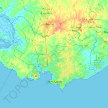
Name: Montevideo topographic map, elevation, terrain.
Location: Montevideo, Uruguay (-34.93806 -56.43140 -34.70185 -56.02250)
Average elevation: 75 ft
Minimum elevation: -13 ft
Maximum elevation: 384 ft
Make a donation
Gear up for your next adventure:
As an Amazon Associate, this site earns from qualifying purchases at no extra cost to you.
Other topographic maps
Click on a map to view its topography, its elevation and its terrain.