
Potter topographic map
Click on the map to display elevation.
About this map
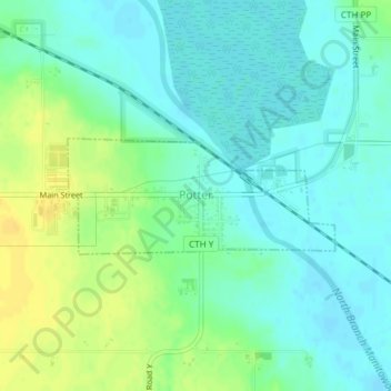
Name: Potter topographic map, elevation, terrain.
Location: Potter, Calumet County, Wisconsin, 54160, United States (44.11644 -88.11159 44.12445 -88.08585)
Average elevation: 827 ft
Minimum elevation: 797 ft
Maximum elevation: 879 ft
Calumet County trails, hiking, mountain biking, running and outdoor activities
Other topographic maps
Click on a map to view its topography, its elevation and its terrain.
Calumet County Park
United States > Wisconsin > Calumet County > Rockaway Beach
Average elevation: 843 ft