Comanche topographic map
Interactive map
Click on the map to display elevation.
About this map
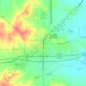
Name: Comanche topographic map, elevation, terrain.
Location: Comanche, Comanche County, Texas, 76442, United States (31.88257 -98.63345 31.92577 -98.58180)
Average elevation: 1,394 ft
Minimum elevation: 1,316 ft
Maximum elevation: 1,519 ft
Other topographic maps
Click on a map to view its topography, its elevation and its terrain.
Energy
United States > Texas > Comanche County
Energy, Comanche County, Texas, 76452, United States
Average elevation: 1,391 ft
Gustine
United States > Texas > Comanche County
Gustine, Comanche County, Texas, 76455, United States
Average elevation: 1,158 ft
Lamkin
United States > Texas > Comanche County
Lamkin, Comanche County, Texas, United States
Average elevation: 1,102 ft
De Leon
United States > Texas > Comanche County
De Leon, Comanche County, Texas, United States
Average elevation: 1,309 ft
Sidney
United States > Texas > Comanche County
Sidney, Comanche County, Texas, 76474, United States
Average elevation: 1,450 ft