Geolocate

Fremont topographic map

Click on the map to display elevation.

About this map

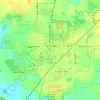
Name: Fremont topographic map, elevation, terrain.

Location: Fremont, Steuben County, Indiana, 46737, United States (41.71598 -84.95466 41.74336 -84.91536)

Average elevation: 1,050 ft

Minimum elevation: 997 ft

Maximum elevation: 1,093 ft

Steuben County trails, hiking, mountain biking, running and outdoor activities

Other topographic maps

Click on a map to view its topography, its elevation and its terrain.

Moonlight

United States > Indiana > Steuben County

Average elevation: 974 ft

Circle Park

United States > Indiana > Steuben County > Hamilton

Average elevation: 932 ft

Lake James

United States > Indiana > Steuben County

Average elevation: 994 ft

Gear up for your next adventure:

📶Satellite Messenger - Communication device off‑grid
🧢Outdoor Hiking Hat - Sun protection hat for outdoor explorers
🎒Waterproof Dry Bags - Keep your electronics and maps dry inside your pack
🧥Men's Rain Shells - Premium waterproof and breathable jackets for mountain weather
🪶Trail Camera - Capture wildlife on your hikes

As an Amazon Associate, this site earns from qualifying purchases at no extra cost to you.