
Make a donation
Gear up for your next adventure:
As an Amazon Associate, this site earns from qualifying purchases at no extra cost to you.
Kleinbardorf topographic map
Click on the map to display elevation.
Make a donation
Gear up for your next adventure:
As an Amazon Associate, this site earns from qualifying purchases at no extra cost to you.
About this map
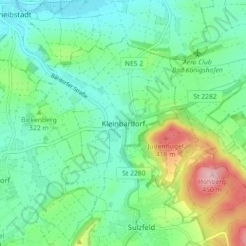
Name: Kleinbardorf topographic map, elevation, terrain.
Average elevation: 1,017 ft
Minimum elevation: 853 ft
Maximum elevation: 1,447 ft
Make a donation
Gear up for your next adventure:
As an Amazon Associate, this site earns from qualifying purchases at no extra cost to you.
Other topographic maps
Click on a map to view its topography, its elevation and its terrain.
Bad Neustadt an der Saale
Deutschland > Bayern > Landkreis Rhön-Grabfeld
Wann die neue Stadt auf dem Hügel am Zusammenfluss von Brend und Fränkischer Saale gegründet wurde, ist nicht bekannt. Grabungsfunde belegen jedoch, dass im 12./13. Jahrhundert eine hölzerne Stadtbefestigungsanlage die neue Siedlung umgab. Die danach errichtete mittelalterliche Stadtmauer aus Stein ist…
Average elevation: 955 ft
Fladungen
Deutschland > Bayern > Landkreis Rhön-Grabfeld
Die Altstadt ist noch weitgehend mit einer Stadtmauer aus dem Jahr 1335 in ihrer ursprünglichen Höhe umgeben. Die Stadtmauer wurde damals mit fünf Türmen und 16 Reitertürmchen erbaut. Alle Türme in der Stadtmauer und die Reitertürmchen auf der Mauerkrone sind erhalten geblieben. Die Altstadt hat viele…
Average elevation: 1,785 ft
Bischofsheim in der Rhön
Deutschland > Bayern > Landkreis Rhön-Grabfeld
Gerade die Ortslage an einem Berg legt aber eine andere Erklärung für den Ortsnamen nahe. Sie folgt der vaskonischen Hypothese. Der Münchner Sprachwissenschaftler Theo Vennemann, der diese Hypothese vertritt, verweist darauf, dass existierende Toponyme (Ortsnamen) in der Regel von Neueinwanderern…
Average elevation: 1,959 ft
Make a donation
Gear up for your next adventure:
As an Amazon Associate, this site earns from qualifying purchases at no extra cost to you.
Mellrichstadter Forst
Deutschland > Bayern > Landkreis Rhön-Grabfeld
Der Mellrichstadter Forst liegt etwa zwölf Kilometer nordwestlich der namensgebenden Stadt Mellrichstadt, zwischen Rhön und Grabfeld. Durch das gemeindefreie Gebiet fließt die Sulz. Die höchste Erhebung im Mellrichstadter Forst ist der Heufurter Kopf mit einer Höhe von 516 m ü. NHN.
Average elevation: 1,470 ft
Sinnquellgebiet und Arnsbergsüdhang
Deutschland > Bayern > Landkreis Rhön-Grabfeld > Bischofsheim i.d.Rhön
Average elevation: 2,287 ft
Make a donation
Gear up for your next adventure:
As an Amazon Associate, this site earns from qualifying purchases at no extra cost to you.
Lichtenburg
Deutschland > Bayern > Landkreis Rhön-Grabfeld > Ostheim v.d.Rhön
Average elevation: 1,296 ft
Make a donation
Gear up for your next adventure:
As an Amazon Associate, this site earns from qualifying purchases at no extra cost to you.
97650
Deutschland > Bayern > Landkreis Rhön-Grabfeld > Fladungen > Oberfladungen
Average elevation: 1,526 ft
97653
Deutschland > Bayern > Landkreis Rhön-Grabfeld > Bischofsheim i.d.Rhön > Frankenheim
Average elevation: 1,749 ft
Make a donation
Gear up for your next adventure:
As an Amazon Associate, this site earns from qualifying purchases at no extra cost to you.
Strahlungen
Deutschland > Bayern > Landkreis Rhön-Grabfeld
Die Gemeinde liegt in der Region Main-Rhön auf einer Anhöhe, von der aus man einen schönen Blick auf das Mittelgebirge Rhön hat. Der am tiefsten gelegene Punkt befindet sich auf etwa 260 m ü. NHN Richtung Salz und der höchste auf etwa 400 m ü. NHN bei Rheinfeldshof. Die nächstgelegenen Städte sind…
Average elevation: 1,033 ft
Make a donation
Gear up for your next adventure:
As an Amazon Associate, this site earns from qualifying purchases at no extra cost to you.
Brend
Deutschland > Bayern > Landkreis Rhön-Grabfeld
Die Brend entspringt in der Rhön aus mehreren Quellen zwischen Gersfeld und Bischofsheim in der Rhön. Die Hauptquelle liegt in Hessen südöstlich vom Ortsteil Rodenbach am Fuße des Simmelsberges (843 m ü. NHN). Sie befindet sich nahe der Landesgrenze, etwa 600 Meter nordöstlich der Passhöhe…
Average elevation: 1,457 ft
Steinacher Forst rechts der Saale
Deutschland > Bayern > Landkreis Rhön-Grabfeld
Average elevation: 1,184 ft
Make a donation
Gear up for your next adventure:
As an Amazon Associate, this site earns from qualifying purchases at no extra cost to you.
Wülfershausen an der Saale
Deutschland > Bayern > Landkreis Rhön-Grabfeld
Nahe der Bundesstraße 279 liegt auf einer leichten Anhöhe vom Friedhof umgeben die romanisch/spätgotische Friedhofskapelle St. Stephan, im Volksmund „Stöffskirch“ genannt. Der alte Friedhof lag vor 1607 um die allererste Pfarrkirche St. Vitus und innerhalb der schützenden Kirchenburg im Dorf. Da…
Average elevation: 974 ft
Make a donation
Gear up for your next adventure:
As an Amazon Associate, this site earns from qualifying purchases at no extra cost to you.
Stockheim
Deutschland > Bayern > Landkreis Rhön-Grabfeld
Zum Dorf gehörten auch zwei Tore. Das Untere Tor stand nach der Brückengasse aus Richtung Mellrichstadt, das Obere Tor war auf Höhe der Gartenstraße, wenn das Dorf von Ostheim kommend auf der Hauptstraße erreicht wird. Über den Bau des Oberen Tores wurde am 30. April 1864 beraten, Brief und Siegel…
Average elevation: 1,191 ft
Unsleben
Deutschland > Bayern > Landkreis Rhön-Grabfeld
Östlich von Unsleben ist der Windpark Streu & Saale der SILA Fünf GmbH & Co. KG in Bau. Er soll im Endausbau 10 Windenergieanlagen des Typs Senvion 3.4M122 mit einer Nabenhöhe von 139 Metern, 122 Meter Rotordurchmesser und 3,4 Megawatt Nennleistung besitzen. Die Jahresenergieproduktion dieses Windparks soll…
Average elevation: 948 ft
Schönau a.d.Brend
Deutschland > Bayern > Landkreis Rhön-Grabfeld > Schönau a.d.Brend
Nördlich von Schönau befindet sich seit 1965 auf dem 425 Meter hohen Markberg das schon von der B 279 aus sichtbare Markbergkreuz. Das erste, 19 Meter hohe Markbergkreuz bestand aus Fichtenholz und wurde 1973 wegen seines schlechten Zustandes durch ein Kreuz gleicher Höhe aus Lärchenholz ersetzt. 1998…
Average elevation: 1,368 ft
Make a donation
Gear up for your next adventure:
As an Amazon Associate, this site earns from qualifying purchases at no extra cost to you.
Make a donation
Gear up for your next adventure:
As an Amazon Associate, this site earns from qualifying purchases at no extra cost to you.
Make a donation
Gear up for your next adventure:
As an Amazon Associate, this site earns from qualifying purchases at no extra cost to you.
97653
Deutschland > Bayern > Landkreis Rhön-Grabfeld > Bischofsheim in der Rhön
Average elevation: 2,018 ft
Bischofsheim in der Rhön
Deutschland > Bayern > Landkreis Rhön-Grabfeld
Gerade die Ortslage an einem Berg legt aber eine andere Erklärung für den Ortsnamen nahe. Sie folgt der vaskonischen Hypothese. Der Münchner Sprachwissenschaftler Theo Vennemann, der diese Hypothese vertritt, verweist darauf, dass existierende Toponyme (Ortsnamen) in der Regel von Neueinwanderern…
Average elevation: 1,959 ft