
Oberelsbach topographic map
Click on the map to display elevation.
About this map
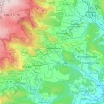
Name: Oberelsbach topographic map, elevation, terrain.
Average elevation: 1,549 ft
Minimum elevation: 902 ft
Maximum elevation: 2,959 ft
Other topographic maps
Click on a map to view its topography, its elevation and its terrain.
Frankenheim
Deutschland > Bayern > Landkreis Rhön-Grabfeld > Bischofsheim in der Rhön
Average elevation: 1,965 ft
Lebenhan
Deutschland > Bayern > Landkreis Rhön-Grabfeld > Bad Neustadt an der Saale
Average elevation: 1,010 ft
Bad Königshofen
Deutschland > Bayern > Landkreis Rhön-Grabfeld > Bad Königshofen im Grabfeld
Average elevation: 1,007 ft
Sondheim
Deutschland > Bayern > Landkreis Rhön-Grabfeld > Mellrichstadt > Sondheim
Average elevation: 1,168 ft
Bischofsheim in der Rhön
Deutschland > Bayern > Landkreis Rhön-Grabfeld > Bischofsheim in der Rhön
Gerade die Ortslage an einem Berg legt aber eine andere Erklärung für den Ortsnamen nahe. Sie folgt der vaskonischen Hypothese. Der Münchner Sprachwissenschaftler Theo Vennemann, der diese Hypothese vertritt, verweist darauf, dass existierende Toponyme (Ortsnamen) in der Regel von Neueinwanderern…
Average elevation: 1,998 ft
Junkershausen
Deutschland > Bayern > Landkreis Rhön-Grabfeld > Wargolshausen
Average elevation: 1,063 ft
Sinnquellgebiet und Arnsbergsüdhang
Deutschland > Bayern > Landkreis Rhön-Grabfeld > Bischofsheim i.d.Rhön
Average elevation: 2,287 ft
Lichtenburg
Deutschland > Bayern > Landkreis Rhön-Grabfeld > Ostheim v.d.Rhön
Average elevation: 1,296 ft
Oberweißenbrunn
Deutschland > Bayern > Landkreis Rhön-Grabfeld > Bischofsheim in der Rhön
Average elevation: 2,287 ft
Bad Neustadt an der Saale
Deutschland > Bayern > Landkreis Rhön-Grabfeld > Bad Neustadt an der Saale
Das Gebiet um die heutige Stadt Bad Neustadt a.d. Saale mit der Königspfalz Salz spielte vom mittleren 8. bis frühen 10. Jahrhunderts eine wichtige Rolle im fränkischen Reich. Die mittelalterlichen Könige und Kaiser übten ihre Herrschaft in Form des „Reisekönigtums“ aus, da es keinen…
Average elevation: 938 ft
Schweinhof
Deutschland > Bayern > Landkreis Rhön-Grabfeld > Bad Neustadt an der Saale > Lebenhan
Average elevation: 997 ft
Unterweißenbrunn
Deutschland > Bayern > Landkreis Rhön-Grabfeld > Bischofsheim i.d.Rhön
Average elevation: 1,562 ft
Sulzdorf an der Lederhecke
Deutschland > Bayern > Landkreis Rhön-Grabfeld > Sulzdorf a.d.Lederhecke
Average elevation: 1,142 ft
Weimarschmieden
Deutschland > Bayern > Landkreis Rhön-Grabfeld > Fladungen
Average elevation: 1,542 ft
Wegfurt
Deutschland > Bayern > Landkreis Rhön-Grabfeld > Bischofsheim in der Rhön
Das Pfarrdorf liegt circa sechs Kilometer südöstlich von Bischofsheim in der Rhön im Tal der Brend auf einer Höhe von 348 m ü. NHN. Etwa neun Kilometer nordöstlich verläuft die Landesgrenze zu Hessen. Die Bundesstraße 279 umgeht den Ortskern auf der nordöstlichen Seite.
Average elevation: 1,299 ft
Urspringen
Deutschland > Bayern > Landkreis Rhön-Grabfeld > Ostheim vor der Rhön
Average elevation: 1,394 ft
Kreuzberg (Rhön)
Deutschland > Bayern > Landkreis Rhön-Grabfeld > Bischofsheim in der Rhön
Der Kreuzberg (früher Aschberg genannt) ist ein 927,8 m ü. NHN hoher Berg der Rhön; nach der Wasserkuppe (950 m; höchster Berg Hessens) und der bayerisch-hessischen Dammersfeldkuppe (927,9 m; Gipfellage in Bayern) ist er der dritthöchste Rhönberg und nach der 0,1 m höheren Dammersfeldkuppe der…
Average elevation: 2,477 ft
Steinernes Haus
Deutschland > Bayern > Landkreis Rhön-Grabfeld > Oberelsbach
Average elevation: 2,362 ft
Löhrieth
Deutschland > Bayern > Landkreis Rhön-Grabfeld > Bad Neustadt an der Saale > Löhrieth
Die etwa 300 Jahre alte Dorflinde, eine Winterlinde, hat einen Umfang von 5,30 Meter, sie hat eine Höhe von 18 m erreicht (siehe Liste der Naturdenkmäler im Landkreis Rhön-Grabfeld).
Average elevation: 1,093 ft
Kleiner Lindenberg
Deutschland > Bayern > Landkreis Rhön-Grabfeld > Ostheim v.d.Rhön
Average elevation: 1,152 ft
Kollertshof
Deutschland > Bayern > Landkreis Rhön-Grabfeld > Schönau a.d.Brend
Average elevation: 1,158 ft