
Make a donation
Gear up for your next adventure:
As an Amazon Associate, this site earns from qualifying purchases at no extra cost to you.
Hirnstetten topographic map
Click on the map to display elevation.
Make a donation
Gear up for your next adventure:
As an Amazon Associate, this site earns from qualifying purchases at no extra cost to you.
Hirnstetten
Das Kirchdorf im Naturpark Altmühltal liegt inmitten einer Rodungsinsel auf der Jurahochfläche nordwestlich von Kipfenberg auf ca. 530 Meter Meereshöhe.
Make a donation
Gear up for your next adventure:
As an Amazon Associate, this site earns from qualifying purchases at no extra cost to you.
About this map
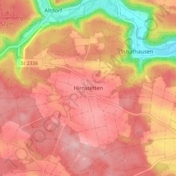
Name: Hirnstetten topographic map, elevation, terrain.
Average elevation: 1,654 ft
Minimum elevation: 1,296 ft
Maximum elevation: 1,824 ft
Make a donation
Gear up for your next adventure:
As an Amazon Associate, this site earns from qualifying purchases at no extra cost to you.
Other topographic maps
Click on a map to view its topography, its elevation and its terrain.
Beilngries
Deutschland > Bayern > Landkreis Eichstätt
Auf einer Anhöhe oberhalb der Stadt Beilngries liegt das Schloss Hirschberg. Es wurde im 20. Jahrhundert zum Bistumshaus umgestaltet, unter anderem durch Erweiterungsbauten wie eine von Alexander von Branca entworfene Kapelle. Karljosef Schattner errichtete von 1987 bis 1992 den Neubau.
Average elevation: 1,575 ft
Eichstätt
Deutschland > Bayern > Landkreis Eichstätt
Die Stadt gilt als Hauptort des Altmühltals. Der nördliche Talabhang oberhalb der Stadt bildet einen Ausläufer des Fränkischen Jura. Höchster Punkt im Stadtgebiet ist mit 574 Metern Höhe eine ehemalige Abraumhalde nahe dem Gemeindeteil Lüften. Am tiefsten Punkt, bei 384 Meter, verlässt die Altmühl das…
Average elevation: 1,608 ft
Make a donation
Gear up for your next adventure:
As an Amazon Associate, this site earns from qualifying purchases at no extra cost to you.
Make a donation
Gear up for your next adventure:
As an Amazon Associate, this site earns from qualifying purchases at no extra cost to you.
Wettstetten
Deutschland > Bayern > Landkreis Eichstätt
Über Jahrhunderte waren Dörfer dieser Art von der Bauernarbeit geprägt, wobei ergänzend gesagt werden kann, dass nach frühen Aufzeichnungen (z. B. 1447/48) in Wettstetten schon lange ein höherer Anteil von sogenannten Kleingütlern existierte, eine Art Landproletariat, das mehr und mehr außerhalb der…
Average elevation: 1,434 ft
Make a donation
Gear up for your next adventure:
As an Amazon Associate, this site earns from qualifying purchases at no extra cost to you.
Pförring
Deutschland > Bayern > Landkreis Eichstätt
Der Ort liegt in der Hallertau in den Ebenen der Donauauen, an deren Altwasser, welche vom Kelsbach gespeist werden. Die Donau fließt unmittelbar südlich am Ort vorbei. Nördlich erstrecken sich die sanft hügeligen Anhöhen des beginnenden Jura. Pförring ist 25 Kilometer von Ingolstadt und 95 Kilometer von…
Average elevation: 1,250 ft
Make a donation
Gear up for your next adventure:
As an Amazon Associate, this site earns from qualifying purchases at no extra cost to you.
Make a donation
Gear up for your next adventure:
As an Amazon Associate, this site earns from qualifying purchases at no extra cost to you.
Mörnsheim
Deutschland > Bayern > Landkreis Eichstätt
Aufgrund der Funde von H. Mayer kann davon ausgegangen werden, dass die Anhöhen um Mörnsheim bereits seit der Bronzezeit besiedelt waren.
Average elevation: 1,657 ft
Make a donation
Gear up for your next adventure:
As an Amazon Associate, this site earns from qualifying purchases at no extra cost to you.
92339
Deutschland > Bayern > Landkreis Eichstätt > Beilngries > Paulushofen > Leising
Average elevation: 1,572 ft
Walting
Deutschland > Bayern > Landkreis Eichstätt
Im Gemeindeteil Walting birgt die erhöht gelegene, ursprünglich befestigte Pfarrkirche St. Johannes, Apostel und Evangelist einen Hochaltar aus dem Ende des 17. Jahrhunderts und mehrere gotische Plastiken. Die mittelalterliche Kapelle St. Leonhard in der Ortsmitte hat ein Deckengemälde von 1732 und einen…
Average elevation: 1,516 ft
Make a donation
Gear up for your next adventure:
As an Amazon Associate, this site earns from qualifying purchases at no extra cost to you.
Titting
Deutschland > Bayern > Landkreis Eichstätt
Die weitverzweigte Gemeinde liegt im Bereich der südlichen Frankenalb nördlich von Eichstätt. Die Gemeindeteile sind teilweise im Anlautertal bzw. in Nachbartälern und teilweise auf den umgebenden Jurahöhen zu finden.
Average elevation: 1,739 ft
Denkendorf
Deutschland > Bayern > Landkreis Eichstätt
Russland Russland: Seit dem Jahr 1980 hegt die Gemeinde Denkendorf freundschaftliche Beziehungen zum Moskauer Stadtteil Krasnaja Presnja. Damals reisten Bürgermeister, Arzt, Pfarrer und die Blaskapelle nach Moskau und sorgten mit Hilfe von Freibier und einem Standkonzert auf dem Roten Platz für…
Average elevation: 1,637 ft
Make a donation
Gear up for your next adventure:
As an Amazon Associate, this site earns from qualifying purchases at no extra cost to you.