
Kinding topographic map
Click on the map to display elevation.
About this map
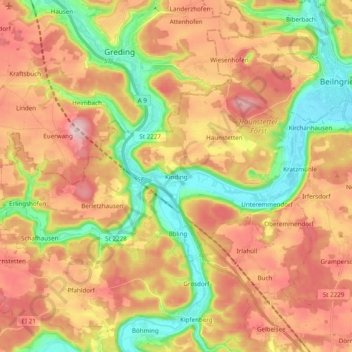
Name: Kinding topographic map, elevation, terrain.
Location: Kinding, Landkreis Eichstätt, Bayern, 85125, Deutschland (48.96966 11.28551 49.03241 11.47919)
Average elevation: 1,578 ft
Minimum elevation: 1,198 ft
Maximum elevation: 1,942 ft
Other topographic maps
Click on a map to view its topography, its elevation and its terrain.
Kasing
Deutschland > Bayern > Landkreis Eichstätt > Kösching
Kasing liegt am Rande des Naturparks Altmühltal, dem drittgrößten Waldgebiets Deutschlands. Dieses liegt ungefähr 4 km von der Marktgemeinde Kösching entfernt. Die geographische Höhe ist ungefähr 380 m ü. NHN.
Average elevation: 1,358 ft
Paulushofen
Deutschland > Bayern > Landkreis Eichstätt > Beilngries > Paulushofen
Average elevation: 1,509 ft
Hirnstetten
Deutschland > Bayern > Landkreis Eichstätt
Das Kirchdorf im Naturpark Altmühltal liegt inmitten einer Rodungsinsel auf der Jurahochfläche nordwestlich von Kipfenberg auf ca. 530 Meter Meereshöhe.
Average elevation: 1,654 ft
Preith
Deutschland > Bayern > Landkreis Eichstätt
Die der hl. Brigida geweihte katholische Pfarrkirche ist eine mittelalterliche Wehrkirche, die noch heute von einer (nicht mehr in ursprünglicher Höhe erhaltenen) Mauer umgeben wird und an der Südwestseite dieses Berings einen zweigeschossigen Torturm mit Satteldach aufweist. Innerhalb des Berings befand…
Average elevation: 1,742 ft
Pfahldorf
Deutschland > Bayern > Landkreis Eichstätt
Das Pfarrdorf liegt im Naturpark Altmühltal auf der Jurahochfläche nordwestlich von Kipfenberg auf ca. 505 Meter Meereshöhe.
Average elevation: 1,611 ft
Steinsdorf
Deutschland > Bayern > Landkreis Eichstätt
Ein „Stainesdorf“ wurde im Jahre 955 erstmals urkundlich erwähnt; ob es sich um das Steinsdorf südlich des Schambachtales auf der Jurahöhe handelt, ist nicht gesichert. Die nächste gesicherte urkundliche Erwähnung stammt mit der Namensnennung von „Pero von Steinesdorf“ aus dem Jahr 1120.
Average elevation: 1,447 ft
Altendorf
Deutschland > Bayern > Landkreis Eichstätt
Die auf 425 m Meereshöhe am südlichen Hang des Gailachtales malerisch gelegene katholische Kirche gehört als Filiale zur Pfarrei Mörnsheim. 1401 fanden eine Rekonziliation der Kirche und Konsekration zweier Altäre statt. Die Chormauern und wohl auch die Chorwölbung sind noch gotisch. Das heutige Langhaus…
Average elevation: 1,588 ft
Hirschberg
Deutschland > Bayern > Landkreis Eichstätt > Beilngries
Das Kirchdorf Hirschberg liegt nordwestlich von Beilngries oberhalb des Altmühltals auf circa 490 m Meereshöhe. Das Dorf breitet sich westlich einer von Schloss Hirschberg beherrschten Bergzunge, dem Hirschberg, auf dem Hochplateau der Fränkischen Alb aus. Durch den Ort führt in gerader Linie die…
Average elevation: 1,476 ft
Rupertsbuch
Deutschland > Bayern > Landkreis Eichstätt
1808 bildete Rupertsbuch zusammen mit Sappenfeld, Schönau und Schernfeld mit Harthof den Steuerdistrikt Schernfeld. Seit 1818 gehörte Rupertsbuch zur Gemeinde Workerszell, wobei der Ferdinandshof, das ehemalige herzogliche Gestüt Geländer und das Gut Sperberslohe mit eingeschlossen waren. 1910 wurde der…
Average elevation: 1,775 ft
Workerszell
Deutschland > Bayern > Landkreis Eichstätt
Das Dorf Workerszell liegt nördlich der Kreisstadt Eichstätt in einer Senkung auf der Fränkischen Alb an der Kreuzung der Straßen Rupertsbuch – Petershöhe und Rupertsbuch – Seuversholz.
Average elevation: 1,772 ft
Attenzell
Deutschland > Bayern > Landkreis Eichstätt
Die etwa 30 m tiefe Schachthöhle erscheint in der Literatur auch als „Arndthöhle“ oder „Arngrube“. Es handelt sich hierbei um einen Einbruch unterirdischer Karsthohlräume. Die Höhle liegt bei N48°54.777' und E11°23.718' auf 468 m Meereshöhe am Rand einer felsigen Mulde und ist bis zu ihrem…
Average elevation: 1,506 ft
Wimpasing
Deutschland > Bayern > Landkreis Eichstätt > Eichstätt > Eichstätt
Average elevation: 1,650 ft
Weiher
Deutschland > Bayern > Landkreis Eichstätt > Mindelstetten > Offendorf
Average elevation: 1,339 ft
Weißendorf
Deutschland > Bayern > Landkreis Eichstätt > Oberdolling > Unterdolling
Average elevation: 1,368 ft
Biber
Deutschland > Bayern > Landkreis Eichstätt > Altmannstein
Das Straßendorf liegt im Landkreis Eichstätt auf circa 430 m Meereshöhe etwa einen halben Kilometer südlich von Mendorf an der dort nach Oberdolling führenden Staatsstraße 2231 und am östlichen Rande des Köschinger Forstes.
Average elevation: 1,398 ft
Laimerstadt
Deutschland > Bayern > Landkreis Eichstätt > Laimerstadt
Das Kirchdorf liegt in den sanft hügeligen Anhöhen des hier beginnenden Jura an der Staatsstraße 2232 etwa 8 km südlich des Altmühltales. Die weiten Ebenen des Donautales befinden sich ca. 10 km südlich des Dorfes.
Average elevation: 1,398 ft
Tettenwang
Deutschland > Bayern > Landkreis Eichstätt
Tettenwang liegt in den leicht hügeligen Anhöhen des hier beginnenden Jura. Die weiten Ebenen des Donautales befinden sich etwa zehn Kilometer südlich des Dorfes.
Average elevation: 1,411 ft