Geolocate

Viós topographic map

Click on the map to display elevation.

About this map

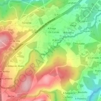
Name: Viós topographic map, elevation, terrain.

Location: Viós, Abegondo, La Coruña, Galicia, España (43.18677 -8.30195 43.20942 -8.27136)

Average elevation: 610 ft

Minimum elevation: 289 ft

Maximum elevation: 1,053 ft

Other topographic maps

Click on a map to view its topography, its elevation and its terrain.

Capela

España > Galicia > La Coruña > Abegondo > Orto de Arriba

Average elevation: 194 ft

Xuanzo

España > Galicia > La Coruña > Abegondo

Average elevation: 427 ft

Longueiral

España > Galicia > La Coruña > Abegondo > O Nogueiral

Average elevation: 492 ft

A Picota

España > Galicia > La Coruña > Abegondo

Average elevation: 482 ft

Gear up for your next adventure:

🗺️Topographic Maps - Detailed topo maps for hiking, exploring and outdoor navigation
🪶Paracord Bracelet - Survival bracelet with built‑in tools
📻Weather Alert Radios - Stay informed of storm risks while off-the-grid
📱Solar Portable Charger - Solar power bank for charging devices off‑grid
🔭Compact Binoculars - HD vision for scouting terrain and identifying distant landmarks

As an Amazon Associate, this site earns from qualifying purchases at no extra cost to you.