Geolocate

Shingatar topographic map

Click on the map to display elevation.

About this map

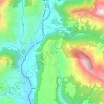
Name: Shingatar topographic map, elevation, terrain.

Location: Shingatar, Tripura Sundari, Dhading, Bagamati Province, Nepal (28.02282 84.80235 28.06282 84.84235)

Average elevation: 2,244 ft

Minimum elevation: 1,509 ft

Maximum elevation: 3,704 ft

Other topographic maps

Click on a map to view its topography, its elevation and its terrain.

Netrawati Dabjong

Nepal > Bagamati Province > Dhading

Average elevation: 3,842 ft

Nilakantha

Nepal > Bagamati Province > Dhading

Average elevation: 3,363 ft

Gangajamuna

Nepal > Bagamati Province > Dhading

Average elevation: 4,961 ft

Gear up for your next adventure:

🏔️Mountain Trail Maps - High‑detail maps for popular peaks
🌧️Backpack Rain Cover - Keep gear dry in wet weather
📱Heavy-Duty Phone Cases - Drop-proof and waterproof protection for outdoor navigation
🥾Women's Hiking Boots - Top-rated trail boots with ankle support and superior grip
📦Gear Storage Bags - Organize and protect outdoor equipment

As an Amazon Associate, this site earns from qualifying purchases at no extra cost to you.