
Elk City topographic map
Interactive map
Click on the map to display elevation.
About this map
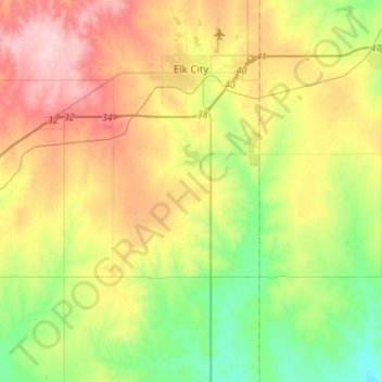
Name: Elk City topographic map, elevation, terrain.
Location: Elk City, Beckham County, Oklahoma, United States (35.24023 -99.63995 35.44341 -99.36420)
Average elevation: 1,929 ft
Minimum elevation: 1,663 ft
Maximum elevation: 2,293 ft
Elk City is located in northeastern Beckham County at 35°24′10″N 99°25′26″W / 35.40278°N 99.42389°W / 35.40278; -99.42389 (35.402694, -99.423812), elevation 1,928 feet (588 m).
Other topographic maps
Click on a map to view its topography, its elevation and its terrain.
Texola
United States > Oklahoma > Beckham County
Texola, Beckham County, Oklahoma, 73668, United States
Average elevation: 2,146 ft
Sweetwater
United States > Oklahoma > Beckham County
Sweetwater, Beckham County, Oklahoma, 73666, United States
Average elevation: 2,175 ft
Erick
United States > Oklahoma > Beckham County
Erick, Beckham County, Oklahoma, 73645, United States
Average elevation: 2,070 ft
Sayre
United States > Oklahoma > Beckham County
Sayre, Beckham County, Oklahoma, 73662, United States
Average elevation: 1,860 ft
Sayre
United States > Oklahoma > Beckham County > Sayre > Sayre
Sayre, Beckham County, Oklahoma, 73662, United States
Average elevation: 1,837 ft
Sayre
United States > Oklahoma > Beckham County
Sayre, Beckham County, Oklahoma, 73662, United States
Average elevation: 1,860 ft