
Mount Roberta topographic map
Click on the map to display elevation.
About this map
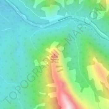
Name: Mount Roberta topographic map, elevation, terrain.
Location: Mount Roberta, Division No. 15, Alberta, Canada (50.63373 -115.05272 50.63383 -115.05262)
Average elevation: 6,729 ft
Minimum elevation: 6,004 ft
Maximum elevation: 8,655 ft
Other topographic maps
Click on a map to view its topography, its elevation and its terrain.
Bow Lake
Canada > Alberta > Division No. 15
Bow Lake is a small lake in western Alberta, Canada. It is located on the Bow River, in the Canadian Rockies, at an altitude of 1920 m.
Average elevation: 7,103 ft