Geolocate

Reagan Wells topographic map

Click on the map to display elevation.

About this map

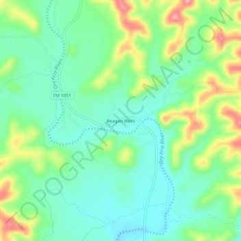
Name: Reagan Wells topographic map, elevation, terrain.

Location: Reagan Wells, Uvalde County, Texas, United States (29.51884 -99.85700 29.55884 -99.81700)

Average elevation: 1,585 ft

Minimum elevation: 1,437 ft

Maximum elevation: 1,886 ft

Uvalde County trails, hiking, mountain biking, running and outdoor activities

Other topographic maps

Click on a map to view its topography, its elevation and its terrain.

Uvalde

United States > Texas > Uvalde County

Average elevation: 919 ft

Onion Creek

United States > Texas > Uvalde County

Average elevation: 1,339 ft

Sabinal

United States > Texas > Uvalde County

Average elevation: 948 ft

Gear up for your next adventure:

🖼️Topo Map Wall Art - Decorative topographic prints of famous peaks and regions
📦Gear Storage Bags - Organize and protect outdoor equipment
🪓Survival Multi‑Tool - Versatile tool for camp and trail tasks
📱Heavy-Duty Phone Cases - Drop-proof and waterproof protection for outdoor navigation
🎒Waterproof Dry Bags - Keep your electronics and maps dry inside your pack

As an Amazon Associate, this site earns from qualifying purchases at no extra cost to you.