Geolocate

Uvalde topographic map

Click on the map to display elevation.

About this map

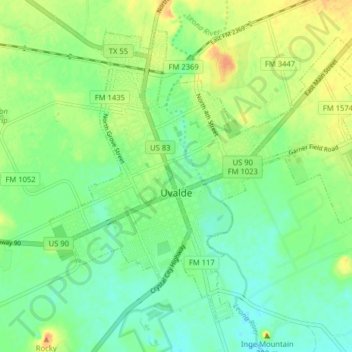
Name: Uvalde topographic map, elevation, terrain.

Location: Uvalde, Uvalde County, Texas, United States (29.18397 -99.81494 29.24162 -99.73534)

Average elevation: 919 ft

Minimum elevation: 873 ft

Maximum elevation: 988 ft

Uvalde County trails, hiking, mountain biking, running and outdoor activities

Other topographic maps

Click on a map to view its topography, its elevation and its terrain.

Blue Mountain

United States > Texas > Uvalde County

Average elevation: 1,017 ft

Onion Creek

United States > Texas > Uvalde County

Average elevation: 1,339 ft

Reagan Wells

United States > Texas > Uvalde County

Average elevation: 1,585 ft

Montell

United States > Texas > Uvalde County

Average elevation: 1,329 ft

Laguna

United States > Texas > Uvalde County

Average elevation: 1,171 ft

Uvalde Estates

United States > Texas > Uvalde County

Average elevation: 948 ft

Gear up for your next adventure:

🧭Map Reading Tools - Tools and kits for map navigation
🧭Pro Hiking Compasses - High-accuracy liquid-filled compasses for topographic orientation
🛰️Handheld GPS Units - Professional satellite navigators for precise backcountry mapping
🧷Carabiner Set - Durable clips for gear attachment
📡GPS Antenna Upgrade - Enhance GPS reception in remote terrain

As an Amazon Associate, this site earns from qualifying purchases at no extra cost to you.