Geolocate

Coquina Key topographic map

Click on the map to display elevation.

About this map

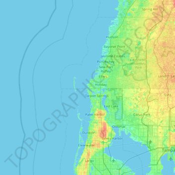
Name: Coquina Key topographic map, elevation, terrain.

Location: Coquina Key, Pasco County, Florida, 34691, United States (27.85556 -83.11417 28.49556 -82.47417)

Average elevation: 16 ft

Minimum elevation: -3 ft

Maximum elevation: 121 ft

Pasco County trails, hiking, mountain biking, running and outdoor activities

Other topographic maps

Click on a map to view its topography, its elevation and its terrain.

Moon Lake

United States > Florida > Pasco County > River Ridge

Average elevation: 39 ft

Shady Hills

United States > Florida > Pasco County

Average elevation: 59 ft

Odessa

United States > Florida > Pasco County

Average elevation: 56 ft

Gear up for your next adventure:

🪑Portable Camp Table - Compact table for campsite meals
🪶Paracord Bracelet - Survival bracelet with built‑in tools
🔭Compact Binoculars - HD vision for scouting terrain and identifying distant landmarks
💧Water Filtration Bottles - Safely drink from streams and lakes while exploring
🧯Portable Fire Pit - Compact fire pit for camping spots

As an Amazon Associate, this site earns from qualifying purchases at no extra cost to you.