
Make a donation
Gear up for your next adventure:
As an Amazon Associate, this site earns from qualifying purchases at no extra cost to you.
Posseck topographic map
Click on the map to display elevation.
Make a donation
Gear up for your next adventure:
As an Amazon Associate, this site earns from qualifying purchases at no extra cost to you.
About this map
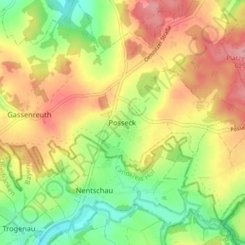
Name: Posseck topographic map, elevation, terrain.
Average elevation: 1,873 ft
Minimum elevation: 1,683 ft
Maximum elevation: 2,067 ft
Make a donation
Gear up for your next adventure:
As an Amazon Associate, this site earns from qualifying purchases at no extra cost to you.
Other topographic maps
Click on a map to view its topography, its elevation and its terrain.
Klingenthal
Deutschland > Sachsen > Vogtlandkreis
Eine weitere bedeutende Veranstaltung ist Mundharmonika-Live an jedem dritten Wochenende im September. Höhepunkt des internationalen Mundharmonikafestivals ist neben den Workshops für Laien und Profis die musikalisch-kulinarische Livenacht mit Mundharmonikamusik in zahlreichen Klingenthaler Gaststätten. Die…
Average elevation: 2,408 ft
Lengenfeld
Deutschland > Sachsen > Vogtlandkreis
Die Stadt liegt in einem Seitental der Göltzsch, knapp 20 km südwestlich von Zwickau und 20 km nordöstlich von Plauen. Sie befindet sich im Osten des Naturraumes Vogtland sowie im sächsischen Teil des historischen Vogtlands. Der Aussichtspunkt „Pilz“ bietet mit einer Höhe von 471 m ü. NHN einen…
Average elevation: 1,440 ft
Make a donation
Gear up for your next adventure:
As an Amazon Associate, this site earns from qualifying purchases at no extra cost to you.