Geolocate

Kinanie ward topographic map

Click on the map to display elevation.

About this map

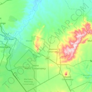
Name: Kinanie ward topographic map, elevation, terrain.

Location: Kinanie ward, Mavoko, Machakos County, Eastern, Kenya (-1.62556 36.97038 -1.31812 37.20241)

Average elevation: 5,302 ft

Minimum elevation: 4,810 ft

Maximum elevation: 6,864 ft

Other topographic maps

Click on a map to view its topography, its elevation and its terrain.

Syokimau

Kenya > Machakos County > Mavoko

Average elevation: 5,308 ft

Athi River

Kenya > Machakos County > Mavoko

Average elevation: 4,987 ft

Gear up for your next adventure:

🛏️Cold Weather Sleeping Bag - Warm sleeping bag for cold conditions
🪓Survival Multi‑Tool - Versatile tool for camp and trail tasks
🧣Merino Neck Gaiters - Multi-functional headwear for wind and sun protection
🧭Map Reading Tools - Tools and kits for map navigation
🪶Compact Camp Shovel - Folding shovel for campsite tasks

As an Amazon Associate, this site earns from qualifying purchases at no extra cost to you.