
Make a donation
Gear up for your next adventure:
As an Amazon Associate, this site earns from qualifying purchases at no extra cost to you.
Upper Japanese Falls topographic map
Click on the map to display elevation.
Make a donation
Gear up for your next adventure:
As an Amazon Associate, this site earns from qualifying purchases at no extra cost to you.
About this map
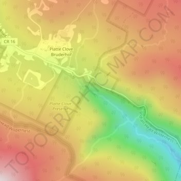
Name: Upper Japanese Falls topographic map, elevation, terrain.
Location: Upper Japanese Falls, Greene County, New York, United States (42.13096 -74.08288 42.13106 -74.08278)
Average elevation: 2,028 ft
Minimum elevation: 817 ft
Maximum elevation: 2,956 ft
Make a donation
Gear up for your next adventure:
As an Amazon Associate, this site earns from qualifying purchases at no extra cost to you.
Other topographic maps
Click on a map to view its topography, its elevation and its terrain.
Cementon
United States > New York > Greene County > Town of Catskill > Cementon
Average elevation: 115 ft
Palenville
United States > New York > Greene County > Town of Catskill > Palenville
Average elevation: 863 ft
Make a donation
Gear up for your next adventure:
As an Amazon Associate, this site earns from qualifying purchases at no extra cost to you.
Village of Catskill
United States > New York > Greene County > Town of Catskill
Average elevation: 62 ft
Make a donation
Gear up for your next adventure:
As an Amazon Associate, this site earns from qualifying purchases at no extra cost to you.
Village of Tannersville
United States > New York > Greene County
Tannersville is located in southern Greene County at 42°11′37″N 74°8′20″W / 42.19361°N 74.13889°W / 42.19361; -74.13889 (42.193619, -74.139011), in the northern part of the town of Hunter. It is situated at an elevation of 1,900 feet (580 m) in the Catskill Mountains just west of the…
Average elevation: 2,011 ft
Make a donation
Gear up for your next adventure:
As an Amazon Associate, this site earns from qualifying purchases at no extra cost to you.
Make a donation
Gear up for your next adventure:
As an Amazon Associate, this site earns from qualifying purchases at no extra cost to you.
Make a donation
Gear up for your next adventure:
As an Amazon Associate, this site earns from qualifying purchases at no extra cost to you.
Platte Clove
United States > New York > Greene County > Town of Hunter > Platte Clove Bruderhof
Average elevation: 1,886 ft
Town of Halcott
United States > New York > Greene County
The pass between Bearpen and neighboring Vly Mountain is traversed by Halcott Mountain Road, an unimproved county highway which reaches 2,800 feet (850 m) at the col, making it the highest elevation free public through road in New York State. It is also the only route between Halcott and the rest of Greene…
Average elevation: 2,362 ft
Make a donation
Gear up for your next adventure:
As an Amazon Associate, this site earns from qualifying purchases at no extra cost to you.
Make a donation
Gear up for your next adventure:
As an Amazon Associate, this site earns from qualifying purchases at no extra cost to you.
Haines Falls
United States > New York > Greene County > Town of Hunter > Haines Falls
Average elevation: 2,057 ft
Make a donation
Gear up for your next adventure:
As an Amazon Associate, this site earns from qualifying purchases at no extra cost to you.
Make a donation
Gear up for your next adventure:
As an Amazon Associate, this site earns from qualifying purchases at no extra cost to you.
Make a donation
Gear up for your next adventure:
As an Amazon Associate, this site earns from qualifying purchases at no extra cost to you.