Geolocate

Arce topographic map

Click on the map to display elevation.

About this map

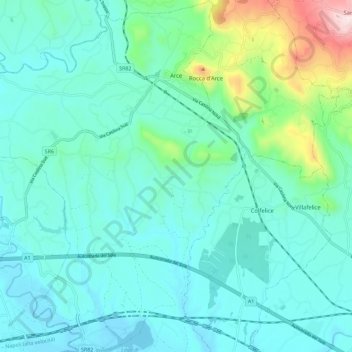
Name: Arce topographic map, elevation, terrain.

Location: Arce, Frosinone, Lazio, 03032, Italy (41.52040 13.50683 41.60597 13.59831)

Average elevation: 640 ft

Minimum elevation: 243 ft

Maximum elevation: 2,507 ft

Other topographic maps

Click on a map to view its topography, its elevation and its terrain.

Monte Sammucro

Italy > Lazio > Frosinone > San Vittore del Lazio

Average elevation: 2,267 ft

San Silvestro

Italy > Lazio > Frosinone > Cassino

Average elevation: 535 ft

Cartiera-Stazione

Italy > Lazio > Frosinone > Ferentino

Average elevation: 561 ft

Colle San Giacomo

Italy > Lazio > Frosinone > Veroli

Average elevation: 2,677 ft

Gear up for your next adventure:

🧭Orienteering Set - Complete compass and map reading kit
🔥Camping Stove - Portable stove for camping and backcountry cooking
📡Handheld GPS Device - Reliable handheld GPS for outdoor navigation
🔋Solar Power Banks - Keep your GPS and phone charged in remote wilderness areas
💧Water Purification System - Clean water on the trail with reliable purifiers

As an Amazon Associate, this site earns from qualifying purchases at no extra cost to you.