Geolocate

Jabba topographic map

Click on the map to display elevation.

About this map

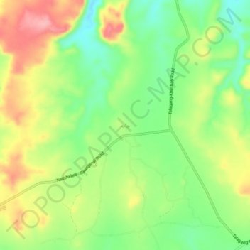
Name: Jabba topographic map, elevation, terrain.

Location: Jabba, Khushab Tehsil, Khushab District, Punjab, Pakistan (32.60749 72.35283 32.64749 72.39283)

Average elevation: 2,539 ft

Minimum elevation: 2,359 ft

Maximum elevation: 2,756 ft

Other topographic maps

Click on a map to view its topography, its elevation and its terrain.

Attock District

Pakistan > Punjab

Average elevation: 1,407 ft

Kalar Kahar Lake

Pakistan > Punjab > Kallar Kahar

Average elevation: 2,195 ft

Gujrat District

Pakistan > Punjab

Average elevation: 853 ft

Faisalabad District

Pakistan > Punjab

Average elevation: 577 ft

Gujujranwala City Tehsil

Pakistan > Punjab

Gujranwala sits at the heart of the Rechna Doab, a strip of land between the Chenab in the north, and Ravi River in the south. Gujranwala is also part of the Majha, a historical region of northern Punjab. The city was built upon the plains of Punjab, and the surrounding region is an unbroken plain devoid of…

Average elevation: 738 ft

Mari Indus

Pakistan > Punjab > Mari Indus

Average elevation: 732 ft

Gujrat

Pakistan > Punjab > Gujrat District

Average elevation: 768 ft

Daska

Pakistan > Punjab

Average elevation: 774 ft

Mughalabad

Pakistan > Punjab > Murree District

Average elevation: 5,833 ft

Gear up for your next adventure:

🦶Hiking Gaiters - Keep debris and water out of your boots
🔭Telescopic Hiking Pole - Adjustable pole for hiking stability
🧣Merino Neck Gaiters - Multi-functional headwear for wind and sun protection
🌡️Portable Weather Meter - Track weather conditions on the trail
🧦Merino Wool Socks - Moisture-wicking, blister-preventing socks for long treks

As an Amazon Associate, this site earns from qualifying purchases at no extra cost to you.