
Make a donation
Gear up for your next adventure:
As an Amazon Associate, this site earns from qualifying purchases at no extra cost to you.
Kingsthorpe topographic map
Click on the map to display elevation.
Make a donation
Gear up for your next adventure:
As an Amazon Associate, this site earns from qualifying purchases at no extra cost to you.
About this map
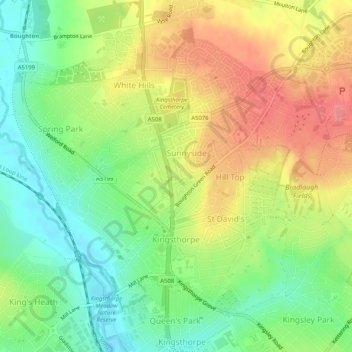
Name: Kingsthorpe topographic map, elevation, terrain.
Location: Kingsthorpe, West Northamptonshire, England, United Kingdom (52.25598 -0.92908 52.28065 -0.87797)
Average elevation: 312 ft
Minimum elevation: 197 ft
Maximum elevation: 443 ft
Make a donation
Gear up for your next adventure:
As an Amazon Associate, this site earns from qualifying purchases at no extra cost to you.
Other topographic maps
Click on a map to view its topography, its elevation and its terrain.
Make a donation
Gear up for your next adventure:
As an Amazon Associate, this site earns from qualifying purchases at no extra cost to you.
Make a donation
Gear up for your next adventure:
As an Amazon Associate, this site earns from qualifying purchases at no extra cost to you.
Make a donation
Gear up for your next adventure:
As an Amazon Associate, this site earns from qualifying purchases at no extra cost to you.
Lower Thorpe
United Kingdom > England > West Northamptonshire > Thorpe Mandeville
Average elevation: 505 ft
Make a donation
Gear up for your next adventure:
As an Amazon Associate, this site earns from qualifying purchases at no extra cost to you.
Upton Country Park
United Kingdom > England > West Northamptonshire > Harpole
Average elevation: 246 ft
Make a donation
Gear up for your next adventure:
As an Amazon Associate, this site earns from qualifying purchases at no extra cost to you.
Abington Park
United Kingdom > England > West Northamptonshire > Northampton
Average elevation: 279 ft
Ravensthorpe Reservoir
United Kingdom > England > West Northamptonshire > Coton
Average elevation: 430 ft
Make a donation
Gear up for your next adventure:
As an Amazon Associate, this site earns from qualifying purchases at no extra cost to you.
Make a donation
Gear up for your next adventure:
As an Amazon Associate, this site earns from qualifying purchases at no extra cost to you.
Courteenhall
United Kingdom > England > West Northamptonshire > Courteenhall
Average elevation: 351 ft
Make a donation
Gear up for your next adventure:
As an Amazon Associate, this site earns from qualifying purchases at no extra cost to you.
Make a donation
Gear up for your next adventure:
As an Amazon Associate, this site earns from qualifying purchases at no extra cost to you.