
Knoxville topographic map
Click on the map to display elevation.
Knoxville
Knoxville features a diverse topography characterized by its position in the Great Appalachian Valley. The city sits at an elevation of approximately 886 feet above sea level, nestled between the Great Smoky Mountains to the east and the Cumberland Plateau to the west. This geographical setup results in a landscape of rolling hills, narrow ridges, and broad valleys, particularly prominent in the Ridge-and-Valley Appalachians subrange. Key topographical features include Sharp's Ridge and Beaver Ridge, which provide natural elevation within the urban area, while the Tennessee River, flowing through downtown Knoxville, enhances the region's beauty with its winding course. The surrounding hills and mountains, including House Mountain, the highest peak in Knox County at 2,064 feet, offer numerous recreational opportunities and scenic vistas, making Knoxville's terrain both visually striking and vital for outdoor activities.
About this map
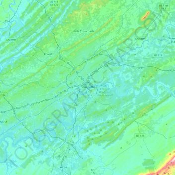
Name: Knoxville topographic map, elevation, terrain.
Average elevation: 1,007 ft
Minimum elevation: 761 ft
Maximum elevation: 2,890 ft
Knox County trails, hiking, mountain biking, running and outdoor activities
Other topographic maps
Click on a map to view its topography, its elevation and its terrain.
House Mountain
United States > Tennessee > Knox County
House Mountain is a mountain located in Corryton, Tennessee, United States, about 8 miles (13 km) northeast of Knoxville. Rising to an elevation of 2,064 feet (629 m) above sea level, House Mountain is the highest point in Knox County.
Average elevation: 1,293 ft