Geolocate

Bonduel topographic map

Click on the map to display elevation.

About this map

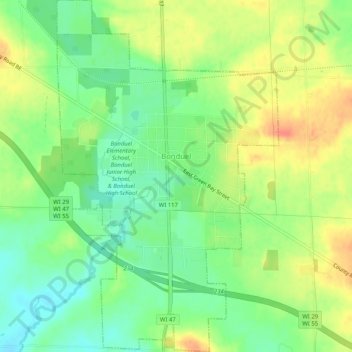
Name: Bonduel topographic map, elevation, terrain.

Location: Bonduel, Shawano County, Wisconsin, United States (44.72008 -88.46214 44.75636 -88.42991)

Average elevation: 909 ft

Minimum elevation: 837 ft

Maximum elevation: 988 ft

Shawano County trails, hiking, mountain biking, running and outdoor activities

Other topographic maps

Click on a map to view its topography, its elevation and its terrain.

Pella

United States > Wisconsin > Shawano County

Average elevation: 922 ft

Pittsfield

United States > Wisconsin > Shawano County

Average elevation: 804 ft

Caroline

United States > Wisconsin > Shawano County

Average elevation: 988 ft

Gear up for your next adventure:

🛠️Outdoor Gear Repair Kit - Essential tools to fix gear on the trail
🧯Portable Fire Pit - Compact fire pit for camping spots
GPS Sports Watch - GPS watch for running, hiking and training
🚁Photography Drones - Capture stunning aerial views of landforms and topography
🌐World Map Poster - Decorative world maps with topographic info

As an Amazon Associate, this site earns from qualifying purchases at no extra cost to you.