
Kispiox topographic map
Click on the map to display elevation.
About this map
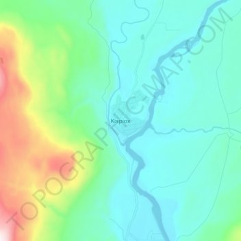
Name: Kispiox topographic map, elevation, terrain.
Average elevation: 1,132 ft
Minimum elevation: 712 ft
Maximum elevation: 3,159 ft
Other topographic maps
Click on a map to view its topography, its elevation and its terrain.
Swan Lake
Canada > British Columbia > Regional District of Kitimat-Stikine > Area B (Suskwa/Kitwanga/Kispiox)
Average elevation: 1,772 ft
Affleck Lake
Canada > British Columbia > Regional District of Kitimat-Stikine > Area B (Suskwa/Kitwanga/Kispiox)
Average elevation: 1,368 ft
Pentz Lake
Canada > British Columbia > Regional District of Kitimat-Stikine > Area B (Suskwa/Kitwanga/Kispiox)
Average elevation: 1,168 ft