Geolocate

Batesville topographic map

Click on the map to display elevation.

About this map

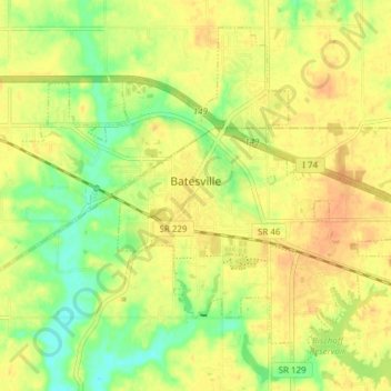
Name: Batesville topographic map, elevation, terrain.

Location: Batesville, Ripley County, Indiana, 47006, United States (39.27223 -85.25602 39.32327 -85.17966)

Average elevation: 965 ft

Minimum elevation: 892 ft

Maximum elevation: 1,014 ft

Ripley County trails, hiking, mountain biking, running and outdoor activities

Other topographic maps

Click on a map to view its topography, its elevation and its terrain.

Delaware

United States > Indiana > Ripley County

Average elevation: 971 ft

Prattsburg

United States > Indiana > Ripley County

Average elevation: 978 ft

Gear up for your next adventure:

🪵Folding Camp Saw - Compact saw for wood and campsite work
🪶Camping Sleeping Pad - Comfortable sleeping pad for backpacking
👓Polarized Sunglasses - Outdoor sunglasses for glare reduction
🥾Men's Hiking Boots - Durable, waterproof footwear for rugged terrain and steep inclines
🌡️Portable Weather Meter - Track weather conditions on the trail

As an Amazon Associate, this site earns from qualifying purchases at no extra cost to you.