Geolocate

Delaware topographic map

Click on the map to display elevation.

About this map

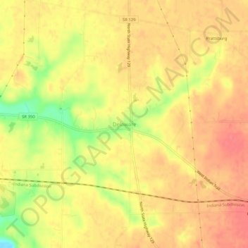
Name: Delaware topographic map, elevation, terrain.

Location: Delaware, Ripley County, Indiana, United States (39.12783 -85.22718 39.16783 -85.18718)

Average elevation: 971 ft

Minimum elevation: 830 ft

Maximum elevation: 1,033 ft

Ripley County trails, hiking, mountain biking, running and outdoor activities

Other topographic maps

Click on a map to view its topography, its elevation and its terrain.

Versailles

United States > Indiana > Ripley County

Average elevation: 938 ft

Osgood

United States > Indiana > Ripley County

Average elevation: 984 ft

Batesville

United States > Indiana > Ripley County

Average elevation: 965 ft

Sunman

United States > Indiana > Ripley County

Average elevation: 1,020 ft

Holton

United States > Indiana > Ripley County

Average elevation: 909 ft

Napoleon

United States > Indiana > Ripley County

Average elevation: 988 ft

Gear up for your next adventure:

🪓Survival Multi‑Tool - Versatile tool for camp and trail tasks
📷Action Cameras - Rugged cameras to document your journeys across rugged terrain
🧭Map Reading Tools - Tools and kits for map navigation
🥾Women's Hiking Boots - Top-rated trail boots with ankle support and superior grip
🏔️Mountain Trail Maps - High‑detail maps for popular peaks

As an Amazon Associate, this site earns from qualifying purchases at no extra cost to you.