
Make a donation
Gear up for your next adventure:
As an Amazon Associate, this site earns from qualifying purchases at no extra cost to you.
Sulzbach/Saar topographic map
Click on the map to display elevation.
Make a donation
Gear up for your next adventure:
As an Amazon Associate, this site earns from qualifying purchases at no extra cost to you.
About this map
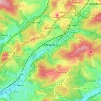
Name: Sulzbach/Saar topographic map, elevation, terrain.
Average elevation: 932 ft
Minimum elevation: 679 ft
Maximum elevation: 1,263 ft
Make a donation
Gear up for your next adventure:
As an Amazon Associate, this site earns from qualifying purchases at no extra cost to you.
Other topographic maps
Click on a map to view its topography, its elevation and its terrain.
Tiefenbachklamm
Deutschland > Saarland > Regionalverband Saarbrücken > Kleinblittersdorf
Average elevation: 886 ft
St. Nikolaus Weiher
Deutschland > Saarland > Regionalverband Saarbrücken > Großrosseln
Average elevation: 833 ft
Make a donation
Gear up for your next adventure:
As an Amazon Associate, this site earns from qualifying purchases at no extra cost to you.
Nagelsberg
Deutschland > Saarland > Regionalverband Saarbrücken > Heusweiler
Average elevation: 827 ft
Staffelberg
Deutschland > Saarland > Regionalverband Saarbrücken > Saarbrücken
Average elevation: 1,086 ft
Großer Homburg
Deutschland > Saarland > Regionalverband Saarbrücken > Saarbrücken
Average elevation: 850 ft
Make a donation
Gear up for your next adventure:
As an Amazon Associate, this site earns from qualifying purchases at no extra cost to you.
Neu-Aschbach
Deutschland > Saarland > Regionalverband Saarbrücken > Saarbrücken
Average elevation: 764 ft
Pfaffenkopf
Deutschland > Saarland > Regionalverband Saarbrücken > Saarbrücken
Average elevation: 965 ft
Make a donation
Gear up for your next adventure:
As an Amazon Associate, this site earns from qualifying purchases at no extra cost to you.
Göttelborn
Deutschland > Saarland > Regionalverband Saarbrücken > Göttelborn
Average elevation: 1,155 ft