
Make a donation
Gear up for your next adventure:
As an Amazon Associate, this site earns from qualifying purchases at no extra cost to you.
Nanjing City topographic map
Click on the map to display elevation.
Make a donation
Gear up for your next adventure:
As an Amazon Associate, this site earns from qualifying purchases at no extra cost to you.
Nanjing City
Jianye (建業, Jiànyè, "Establishing Merit") was adopted as the name of the Wu capital during the Three Kingdoms Era. The city first became an imperial Chinese capital under the Sima Jin dynasty under the name Jiankang, a change adopted to avoid the naming taboo occasioned by the elevation of Emperor Min, whose personal name was Sima Ye. Under the Tang dynasty, it was known as Shengzhou (昇州, Shēngzhōu, "Ascending Prefecture").
Make a donation
Gear up for your next adventure:
As an Amazon Associate, this site earns from qualifying purchases at no extra cost to you.
About this map
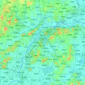
Name: Nanjing City topographic map, elevation, terrain.
Location: Nanjing City, Jiangsu, China (31.22675 118.33459 32.61578 119.23951)
Average elevation: 95 ft
Minimum elevation: -3 ft
Maximum elevation: 1,371 ft
Make a donation
Gear up for your next adventure:
As an Amazon Associate, this site earns from qualifying purchases at no extra cost to you.
Other topographic maps
Click on a map to view its topography, its elevation and its terrain.
Make a donation
Gear up for your next adventure:
As an Amazon Associate, this site earns from qualifying purchases at no extra cost to you.
Make a donation
Gear up for your next adventure:
As an Amazon Associate, this site earns from qualifying purchases at no extra cost to you.
Make a donation
Gear up for your next adventure:
As an Amazon Associate, this site earns from qualifying purchases at no extra cost to you.