
Make a donation
Gear up for your next adventure:
As an Amazon Associate, this site earns from qualifying purchases at no extra cost to you.
Guairá topographic map
Click on the map to display elevation.
Make a donation
Gear up for your next adventure:
As an Amazon Associate, this site earns from qualifying purchases at no extra cost to you.
About this map
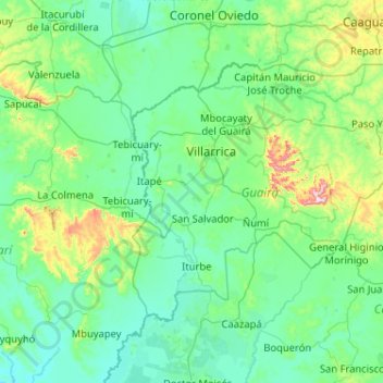
Name: Guairá topographic map, elevation, terrain.
Location: Guairá, Región Oriental, Paraguay (-26.19184 -56.66225 -25.56566 -55.63335)
Average elevation: 531 ft
Minimum elevation: 236 ft
Maximum elevation: 2,661 ft
Make a donation
Gear up for your next adventure:
As an Amazon Associate, this site earns from qualifying purchases at no extra cost to you.
Other topographic maps
Click on a map to view its topography, its elevation and its terrain.
Make a donation
Gear up for your next adventure:
As an Amazon Associate, this site earns from qualifying purchases at no extra cost to you.
Make a donation
Gear up for your next adventure:
As an Amazon Associate, this site earns from qualifying purchases at no extra cost to you.
La Colmena
Paraguay > Department of Paraguari
It is at the northern foot of the Cerro Apitagua, a 25-mile east–west ridge formed by volcanic activity. The steep ascent reaches an altitude of 2,000 feet above sea level in some places. La Colmena is located along the relatively gentle slopes that are between 100 and 400 feet above sea level.
Average elevation: 515 ft
Make a donation
Gear up for your next adventure:
As an Amazon Associate, this site earns from qualifying purchases at no extra cost to you.