
Moscow Kremlin topographic map
Interactive map
Click on the map to display elevation.
About this map
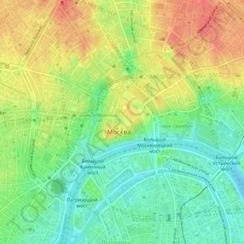
Name: Moscow Kremlin topographic map, elevation, terrain.
Average elevation: 466 ft
Minimum elevation: 384 ft
Maximum elevation: 561 ft
Other topographic maps
Click on a map to view its topography, its elevation and its terrain.
"Золотая миля"
"Золотая миля", Khamovniki District, Moscow, Central Federal District, 119034, Russia
Average elevation: 443 ft
Sokol District
Sokol District, Moscow, Central Federal District, Russia
Average elevation: 531 ft