Geolocate

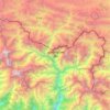
Kharibot topographic map

Click on the map to display elevation.

About this map

Name: Kharibot topographic map, elevation, terrain.

Location: Kharibot, Ajirkot, Gorkha, Gandaki Province, Nepal (28.17639 84.62655 28.21639 84.66655)

Average elevation: 5,105 ft

Minimum elevation: 3,291 ft

Maximum elevation: 7,805 ft

Other topographic maps

Click on a map to view its topography, its elevation and its terrain.
Gorkha

Nepal > Gandaki Province > Gorkha

Average elevation: 2,582 ft

Gorkha

Nepal > Gandaki Province > Gorkha

Average elevation: 2,582 ft

Chum Nubri

Nepal > Gandaki Province > Gorkha

Average elevation: 14,583 ft

Chum Nubri

Nepal > Gandaki Province > Gorkha

Average elevation: 14,583 ft

Aarughat

Nepal > Gandaki Province > Gorkha

Average elevation: 4,833 ft

Gear up for your next adventure:

👟Trail Running Shoes - Lightweight shoes for trail runners
⌚Solar GPS Watches - Advanced multisport watches with built-in topographic maps
🥩Freeze-Dried Meals - Nutritious and lightweight food for remote expeditions
🎒Outdoor Daypacks - Lightweight backpacks designed for carrying maps and essential gear
☀️Outdoor Sunscreen - High protection sunscreen for outdoor activities

As an Amazon Associate, this site earns from qualifying purchases at no extra cost to you.