
阔斯特克镇 topographic map
Interactive map
Click on the map to display elevation.
About this map
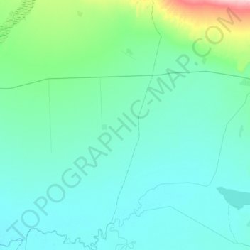
Name: 阔斯特克镇 topographic map, elevation, terrain.
Location: 阔斯特克镇, 布尔津县, 阿勒泰地区, 新疆维吾尔自治区, 中国 (47.57141 87.18652 47.83025 87.35731)
Average elevation: 1,660 ft
Minimum elevation: 1,555 ft
Maximum elevation: 2,379 ft
Other topographic maps
Click on a map to view its topography, its elevation and its terrain.
禾木
中国 > 新疆维吾尔自治区 > 布尔津县 > 禾木哈纳斯蒙古民族乡
禾木, 禾木哈纳斯蒙古民族乡, 布尔津县, 阿勒泰地区, 新疆维吾尔自治区, 中国
Average elevation: 3,927 ft
喀纳斯
中国 > 新疆维吾尔自治区 > 布尔津县 > 禾木哈纳斯蒙古民族乡
喀纳斯, 禾木哈纳斯蒙古民族乡, 布尔津县, 阿勒泰地区, 新疆维吾尔自治区, 中国
Average elevation: 4,882 ft
喀纳斯湖
中国 > 新疆维吾尔自治区 > 布尔津县 > 禾木哈纳斯蒙古民族乡
喀纳斯湖, 禾木哈纳斯蒙古民族乡, 布尔津县, 阿勒泰地区, 新疆维吾尔自治区, 中国
Average elevation: 6,220 ft