Geolocate

Cleveland topographic map

Interactive map

Click on the map to display elevation.

About this map

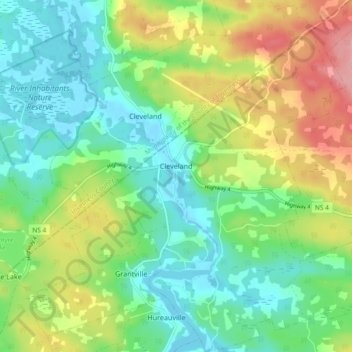
Name: Cleveland topographic map, elevation, terrain.

Location: Cleveland, Municipality of the County of Richmond, Richmond County, Nova Scotia, Canada (45.63372 -61.24964 45.69848 -61.17776)

Average elevation: 131 ft

Minimum elevation: -7 ft

Maximum elevation: 377 ft

Other topographic maps

Click on a map to view its topography, its elevation and its terrain.

Balmoral

Canada > Nova Scotia > Municipality of the County of Richmond

Balmoral, Grande Anse, Municipality of the County of Richmond, Richmond County, Nova Scotia, B0E 3K0, Canada

Average elevation: 180 ft

Flat Rock

Canada > Nova Scotia > Municipality of the County of Richmond > Grand River

Flat Rock, Grand River, Municipality of the County of Richmond, Richmond County, Nova Scotia, Canada

Average elevation: 16 ft

Point Michaud

Canada > Nova Scotia > Municipality of the County of Richmond

Point Michaud, Municipality of the County of Richmond, Richmond County, Nova Scotia, Canada

Average elevation: 39 ft

Louisdale

Canada > Nova Scotia > Municipality of the County of Richmond

Louisdale, Municipality of the County of Richmond, Richmond County, Nova Scotia, B0E 1V0, Canada

Average elevation: 85 ft