Geolocate

Lamporecchio topographic map

Interactive map

Click on the map to display elevation.

About this map

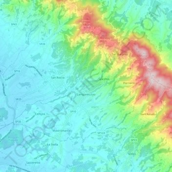
Name: Lamporecchio topographic map, elevation, terrain.

Location: Lamporecchio, Pistoia, Tuscany, 51035, Italy (43.79360 10.82556 43.84715 10.94159)

Average elevation: 433 ft

Minimum elevation: 49 ft

Maximum elevation: 1,706 ft

Other topographic maps

Click on a map to view its topography, its elevation and its terrain.

Cerbaia

Italy > Tuscany > Pistoia

Cerbaia, Lamporecchio, Pistoia, Tuscany, 51036, Italy

Average elevation: 112 ft

Vellano

Italy > Tuscany > Pistoia > Pescia

Vellano, Pescia, Pistoia, Tuscany, 51017, Italy

Average elevation: 1,447 ft

San Marcello Pistoiese

Italy > Tuscany > Pistoia

San Marcello Pistoiese, San Marcello Piteglio, Pistoia, Tuscany, 51028, Italy

Average elevation: 2,382 ft

Pescia

Italy > Tuscany > Pistoia > Pescia

Pescia, Pistoia, Tuscany, 51017, Italy

Average elevation: 1,437 ft

Calamari

Italy > Tuscany > Pistoia > Pescia > Vellano > Calamari

Calamari, Vellano, Pescia, Pistoia, Tuscany, 51017, Italy

Average elevation: 1,299 ft