
Donald Lake topographic map
Click on the map to display elevation.
About this map
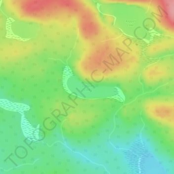
Name: Donald Lake topographic map, elevation, terrain.
Average elevation: 2,651 ft
Minimum elevation: 2,500 ft
Maximum elevation: 2,848 ft
Other topographic maps
Click on a map to view its topography, its elevation and its terrain.
Stuart Lake
Canada > British Columbia > Regional District of Bulkley-Nechako > Area C (Stuart Lake/Omineca Valley)
Average elevation: 2,848 ft
Mount Germansen
Canada > British Columbia > Regional District of Bulkley-Nechako > Area C (Stuart Lake/Omineca Valley)
Average elevation: 5,581 ft
Mount Milligan
Canada > British Columbia > Regional District of Bulkley-Nechako > Area C (Stuart Lake/Omineca Valley)
Average elevation: 3,934 ft
Mount Ogden
Canada > British Columbia > Regional District of Bulkley-Nechako > Area C (Stuart Lake/Omineca Valley)
Average elevation: 5,295 ft
Skeena Mountains
Canada > British Columbia > Regional District of Bulkley-Nechako > Area C (Stuart Lake/Omineca Valley)
Average elevation: 4,393 ft
Smith Island
Canada > British Columbia > Regional District of Bulkley-Nechako > Area C (Stuart Lake/Omineca Valley)
Average elevation: 2,907 ft
Omineca Mountains
Canada > British Columbia > Regional District of Bulkley-Nechako > Area C (Stuart Lake/Omineca Valley)
Average elevation: 3,015 ft