Geolocate

Begovo Razdolje topographic map

Click on the map to display elevation.

Begovo Razdolje

Begovo Razdolje (Croatian pronunciation: [bɛ̂ɡɔʋɔ rǎːzdɔːʎɛ]) is a village in Mrkopalj municipality, Primorje-Gorski Kotar County, Croatia. At 1,060 m (3,478 ft), it is the settlement with the highest elevation in Croatia.

Wikipedia (CC-BY-SA 3.0)

About this map

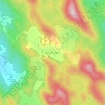
Name: Begovo Razdolje topographic map, elevation, terrain.

Location: Begovo Razdolje, Općina Mrkopalj, Primorje-Gorski Kotar County, Croatia (45.28454 14.88643 45.32454 14.92643)

Average elevation: 3,560 ft

Minimum elevation: 2,779 ft

Maximum elevation: 4,386 ft

Other topographic maps

Click on a map to view its topography, its elevation and its terrain.

Beli

Croatia > Primorje-Gorski Kotar County > Grad Cres

Average elevation: 486 ft

Susak

Croatia > Primorje-Gorski Kotar County > Susak

Located in the Kvarner Bay and southeast of the Istrian peninsula, the Croatian island of Susak is 7.4 kilometers (4.6 mi; 4.0 nmi) southwest from the island of Lošinj, 10 kilometers (6.2 mi; 5.4 nmi) south of the island of Unije, and 120 kilometers (75 mi; 65 nmi) east of the Italian coast. Susak is about 3…

Average elevation: 43 ft

Unije

Croatia > Primorje-Gorski Kotar County > Unije

Average elevation: 16 ft

Grad Cres

Croatia > Primorje-Gorski Kotar County

Average elevation: 203 ft

Kastav

Croatia > Primorje-Gorski Kotar County

Average elevation: 965 ft

Malinska

Croatia > Primorje-Gorski Kotar County

Average elevation: 128 ft

Gear up for your next adventure:

🧣Hiking Neck Gaiter - Multi‑use neck protection for outdoor weather
🔪Outdoor Multitools - Essential survival tools for gear repair and field use
😴Insulated Sleeping Pads - Compact and warm pads for high-elevation camping
🏕️Family Camping Gear - Essentials for group camping trips
🏕️Tent Footprint - Protect your tent base from wear

As an Amazon Associate, this site earns from qualifying purchases at no extra cost to you.