
Make a donation
Gear up for your next adventure:
As an Amazon Associate, this site earns from qualifying purchases at no extra cost to you.
Municipio Iruya topographic map
Click on the map to display elevation.
Make a donation
Gear up for your next adventure:
As an Amazon Associate, this site earns from qualifying purchases at no extra cost to you.
Municipio Iruya
Located in the altiplano region along the Iruya River, Iruya sits nestled against the mountainside at an elevation of 2,780 meters (9,120 feet). It is located over 300 kilometers (190 mi) from the province capital of Salta. There is no direct road connection to the rest of the Salta province and access is through a road to the adjacent Jujuy province, a 50 km (31 mi) portion of which is unpaved. Nonetheless, the town is popular with tourists for its scenic location and townscape and friendly locals. 8 km north of Iruya there is the village of San Isidro, 7 km north there is the village of San Juan, 6 km south there is the village of Pueblo Viejo.
Make a donation
Gear up for your next adventure:
As an Amazon Associate, this site earns from qualifying purchases at no extra cost to you.
About this map
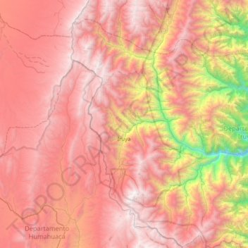
Name: Municipio Iruya topographic map, elevation, terrain.
Average elevation: 11,594 ft
Minimum elevation: 4,528 ft
Maximum elevation: 16,453 ft
Make a donation
Gear up for your next adventure:
As an Amazon Associate, this site earns from qualifying purchases at no extra cost to you.
Other topographic maps
Click on a map to view its topography, its elevation and its terrain.
Colomé
Colomé is a village and rural municipality in Salta Province in northwestern Argentina. It is located about 20 km from Molinos, Salta. This settlement was established by the last Spanish governor of Salta, Nicolás Severo de Isasmendi, in 1831. His daughter Ascención imported grapevines from France and…
Average elevation: 7,520 ft
Make a donation
Gear up for your next adventure:
As an Amazon Associate, this site earns from qualifying purchases at no extra cost to you.
Make a donation
Gear up for your next adventure:
As an Amazon Associate, this site earns from qualifying purchases at no extra cost to you.
Nevado de Quehuar
Argentina > Salta > Municipio de San Antonio de los Cobres
Average elevation: 18,822 ft